Floods are categorized as Riverine, Flash and Localized floods that are mostly urban. Inundation maps were prepared using data obtained through satellite images and
In this flood hazard profile development computation of inundation areas for different return periods using digital elevation model (DEM) based hydrologic
The human, socio-economic and environmental impacts of floods in Sierra Leone has seen a skyrocketing trend over the last decades - Between 1980 and 2010, floods affected approximately 221,204 people, killing some 145 people (11% of people killed by disasters other than the war) [1]. This number has seen an upward trend over the last few years.
On 24 June 2017, heavy downpour of rain flooded two towns of
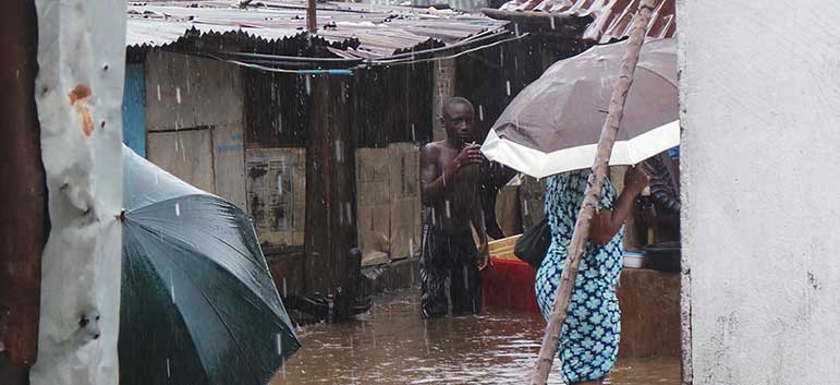
Torrential rainfall in the month of August 2017 led to widespread flooding across different parts of Freetown City. On the same night of the most devastating landslide disaster in Sierra Leone (14 August 2017), torrential rains led to a series of significant floods in several areas of Freetown, including Karningo, Kamayama, Dwarzark, Kroo Bay, Congo Town, Kissy Brook, and Culvert community in Granville Brook.
A health centre, the bridge and a school at Kroo Bay were flooded on the night between Saturday and Sunday 26/27 August 2017 in downtown Freetown, resulting in one fatality and two injuries[3].
In 2015 alone, over 20,000 people were affected by floods in several districts across the country.
On the 23 September 2015, floods ravaged the city of Freetown causing tremendous damage to property, loss of livelihood and displacing over 14,000 people.
National Profile
|
Parameters |
Scale |
||||
|
1 |
2 |
3 |
4 |
5 |
|
|
Frequency |
Very Rarely |
Rarely |
Sometimes |
Often |
Frequently |
|
Magnitude |
Trivial |
Small |
Moderate |
Large |
Very Large |
|
Duration |
Very Short |
Short |
Average |
Long |
Very Long |
|
Areal Extent |
Limited |
Very Sparsely |
Sparsely |
Densely |
Widespread |
|
Spatial Predictability |
Highly Predictable |
Predictable |
Likely |
Randomly |
Very Randomly |
|
Speed of onset |
Very Slow |
Slow |
Moderate |
Fast |
Very Fast |
|
Importance |
Not Important |
Somewhat Important |
Moderately |
Important |
Very Important |
|
Spatial Dispersion |
Very Concentrated |
Concentrated Moderately |
Moderately |
Diffused |
Widely Diffused |
|
Area/District |
Frequency Scale |
Magnitude Scale |
||||||||
|
1 |
2 |
3 |
4 |
5 |
1 |
2 |
3 |
4 |
5 |
|
|
Western Area |
|
|
|
|
|
|
|
|
|
|
|
Bo |
|
|
|
|
|
|
|
|
|
|
|
Bonthe |
|
|
|
|
|
|
|
|
|
|
|
Moyamba |
|
|
|
|
|
|
|
|
|
|
|
Pujehun |
|
|
|
|
|
|
|
|
|
|
|
Bombali |
|
|
|
|
|
|
|
|
|
|
|
Port Loko |
|
|
|
|
|
|
|
|
|
|
|
Tonkolili |
|
|
|
|
|
|
|
|
|
|
|
Kambia |
|
|
|
|
|
|
|
|
|
|
|
Koinadugu |
|
|
|
|
|
|
|
|
|
|
|
Kenema |
|
|
|
|
|
|
|
|
|
|
|
Kono |
|
|
|
|
|
|
|
|
|
|
|
Kailahun |
|
|
|
|
|
|
|
|
|
|
[1] Tarawalli, P. (2012). Diagnostics Analysis of Climate Change and Disaster Management in Relation to the PRSP III in Sierra Leone. Freetown: UNDP - SL.
[2] Bah Saidu. (2017). ‘More Flooding in Eastern Chiefdoms’, Awoko Newspaper, 27 June, p. 6.
[3] Sierra Leone: Landslide and Floods Situation Update no.7, 29 August 2017 (https://reliefweb.int/report/sierra-leone/sierra-leone-landslide-and-floods-situation-update-no7-29-august-2017, accessed 9 September 2017).
[4] International Federation of Red Cross and Red Crescent Societies (MDRSL006). (2015). Sierra Leone Floods, 18 September
[5] Government of Sierra Leone, Ministry of Transport and Aviation. (2007, December). Sierra Leone National Adaptation Programme of Action (NAPA) – Final Report “ – “Government of Sierra Leone. (2006). Initial Communication (INC) in Climate Change” – “Office of National Security. (2004). National Hazard Assessment Profile”.