Coastal erosion in Sierra Leone is accelerated due to anthropogenic activities and poorly planned coastal infrastructure development adding stresses on the coastal ecosystems. The complex coastal environment processes and shoreline stability or the dynamics of accretion or erosion are driven by coastal hydrodynamics, sediment balance and coastal geomorphology etc. influenced by wave climate and shoreline geometry.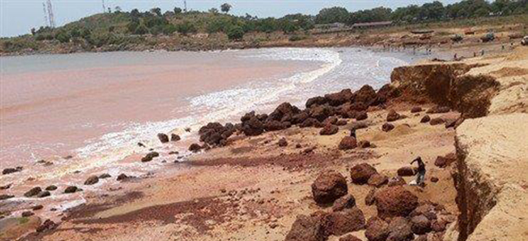
The coastal erosion hazard profile uses a sediment cell approach that considers wave incident angle, sediment balance and length of the cell on the shoreline stability.
The coastal erosion driver significances have been adjusted in the study using the coping capacities corresponding to each cell, based on the physical
Coastal erosion has been and is still posing a serious problem for coastal management authorities and the population in along the coast of Sierra Leone. This phenomenon which is very evident along the Sierra Leone coastline has attained rates of some 4 -6 metres per year in some locations (e.g. Konakridee, Lumley, Lakka, Hamilton etc.)[1]. Other areas with visible erosion signs along
|
Parameters |
Scale |
||||
|
1 |
2 |
3 |
4 |
5 |
|
|
Frequency |
Very Rarely |
Rarely |
Sometimes |
Often |
Frequently |
|
Magnitude |
Trivial |
Small |
Moderate |
Large |
Very Large |
|
Duration |
Very Short |
Short |
Average |
Long |
Very Long |
|
Areal Extent |
Limited |
Very Sparsely |
Sparsely |
Densely |
Widespread |
|
Spatial Predictability |
Highly Predictable |
Predictable |
Likely |
Randomly |
Very Randomly |
|
Speed of onset |
Very Slow |
Slow |
Moderate |
Fast |
Very Fast |
|
Importance |
Not Important |
Somewhat Important |
Moderately |
Important |
Very Important |
|
Spatial Dispersion |
Very Concentrated |
Concentrated Moderately |
Moderately |
Diffused |
Widely Diffused |
District Profile
|
Area/District |
Frequency Scale |
Magnitude Scale |
||||||||
|
1 |
2 |
3 |
4 |
5 |
1 |
2 |
3 |
4 |
5 |
|
|
Western Area |
|
|
|
|
|
|
|
|
|
|
|
Bo |
|
|
|
|
|
|
|
|
|
|
|
Bonthe |
|
|
|
|
|
|
|
|
|
|
|
Moyamba |
|
|
|
|
|
|
|
|
|
|
|
Pujehun |
|
|
|
|
|
|
|
|
|
|
|
Bombali |
|
|
|
|
|
|
|
|
|
|
|
Port Loko |
|
|
|
|
|
|
|
|
|
|
|
Tonkolili |
|
|
|
|
|
|
|
|
|
|
|
Kambia |
|
|
|
|
|
|
|
|
|
|
|
Koinadugu |
|
|
|
|
|
|
|
|
|
|
|
Kenema |
|
|
|
|
|
|
|
|
|
|
|
Kono |
|
|
|
|
|
|
|
|
|
|
|
Kailahun |
|
|
|
|
|
|
|
|
|
|
[1] Johnson, R. G. (2006). Coastal Erosion Issues in Sierra Leone: Adaptation, planning and implementation relating to the Sierra Leone coastal zone. National Adaptation Programme of Action (NAPA) Project for Sierra Leone. UNFCCC African Regional Workshop on Adaptation, Accra. Ghana, September.
[2] Tarawalli, P. (2012). Diagnostics Analysis of Climate Change and Disaster Management in Relation to the PRSP III in Sierra Leone. Freetown: UNDP - SL.