Detailed hazard profiling and assessment of the nine major natural hazards (i.e., landslide, flood, drought, epidemics, coastal erosion, sea level rise, storm surge, tropical storm and lightning and thunder) in Sierra Leone has been undertaken to achieve the objectives of the Project. The comprehensive hazard and risk assessment mapping generated significant findings that
Below is a summary of the key findings of the Project:
- The hazard assessment and mapping revealed that the country is highly prone to flood, landslide and coastal erosion, tropical storms and sea level rise hazards. The high level of population exposure to flood and landslide hazards and coastal erosion and sea level rise hazards is clearly evident in the hilly and low lying areas of the Western Areas and along the coastal areas in the Western Area and the Northern and Southern Provinces of Sierra Leone. For landslide hazards, the identified elements at risk in the study areas
are: population, buildings, education facilities, health facilities and transportation (roads). For flood hazards, the identified elements at risk in the study areasare: population, buildings, agriculture sector (cultivated area and livestock), education facilities, health facilities and transportation (roads). It should be noted that the vulnerability and risk assessments were only undertaken for landslides and floods. The other seven hazards were not assessed in terms of vulnerability and risks due to inadequate data
- The landslide hazard, vulnerability and risk assessment showed that the hilly and steep-sided slope areas in the Western Area, especially in Leicester, Regent, Granville Brook, Cline Town, Moa Wharf, Hill Court Road, Kissy Brook, Dwarzark, and Charlotte in the Mountain Rural District of the Western Area are prone to landslides due to their moderate to very high slope susceptibility and heavy precipitation received in the Wet Season.
- The flood hazard, vulnerability and risk assessment revealed that floods are more likely in areas around the ten catchments analysed close to the estuaries and along the entire coastline of Sierra Leone, based on a 10-year return period. In addition, based on historical flood events data, it also indicated that flood hazards are likely to occur in many different locations in the country; however, due to data
limitations only analysis by catchment was possible for this study. Nonetheless, the study also revealed that parts of Freetown City, including Karningo, Kamayama, Dwarzark, Kroo Bay, Congo Town, Kissy Brook, and Culvert community in Granville Brook are prone to floods due to their moderate to very high slope susceptibility and heavy precipitation received in the Wet Season.
Below is a synopsis of the results
Landslides Hazard Assessment and Mapping
A background and
The impact of landslides and mudslides in Sierra Leone is highly concentrated in the Western Area where the combined effects of steep slopes, heavy rainfall, and unabated deforestation and construction provide a perfect recipe for mass movements. Landslide disasters in Sierra Leone as a whole accounted for 42 percent of nationally reported geophysical/geohazard mortalities between 1990 and 2014. The 14 August 2017 landslide disaster alone left over 500 people dead, some 600 missing, with about 50,000 directly or indirectly affected in the densely populated Freetown. The most severe disaster occurred in Regent and Lumley districts with a massive 6 kilometres mudflow submerging and wiping out over 300 houses along the banks of the Lumley Creek. Leicester, Regent, Granville Brook, Cline Town, Moa Wharf, Hill Court Road, Kissy Brook, Dwarzark, and Charlotte in the Mountain Rural District have been identified as areas prone to landslides.
Flooding Hazard Assessment and Mapping
A brief background on floods in Sierra Leone, including flood hazard mapping and its uses, classification of floods, causative factors of different kinds of floods and their impacts are provided. The section on flood vulnerable areas in the country is interpreted in the form of a flood risk map as well as using historic flood events to assess and map floods. The methodology used is
The human, socio-economic and environmental impacts of floods in Sierra Leone has seen a skyrocketing trend over the last decades - Between 1980 and 2010, floods affected approximately 221,204 people, killing some 145 people. On 24 June 2017, heavy downpour of rain flooded two towns of Largor Jasawabu in the Nongowa Chiefdom and Foindu Mameima in the Lower Bambara Chiefdom, near Kenema. Torrential rainfall in the month of August 2017 led to widespread flooding across different parts of Freetown City, including Karningo, Kamayama, Dwarzark, Kroo Bay, Congo Town, Kissy Brook, and Culvert community in Granville Brook.
Coastal Erosion Hazard Assessment and Mapping
Includes a brief background on coastal hydrodynamics, coastal sediment balance, coastal geography and units,
Coastal erosion in Sierra Leone is accelerated due to anthropogenic activities and poorly planned coastal infrastructure development adding stresses on the coastal ecosystems. Coastal erosion has been and is still posing a serious problem for coastal management authorities and the population in along the coast of Sierra Leone. This phenomenon which is very evident along the Sierra Leone coastline has attained rates of some 4 -6 metres per year in some locations (e.g. Konakridee, Lumley, Lakka, Hamilton etc.).Other areas with visible erosion signs along
Sea Level Rise Hazard Assessment and Mapping
Discusses the role of global warming in sea level rise, the regions that are vulnerable to sea level rise, sea level rise predictions and causative factors. Methodology summarizes the usage of topographic data to identify the coastal areas due to sea level rise. The hazard profile describes the inundation areas of coastal regions of Sierra Leone predicted for 2100. The study recommends that the inundation assessment should be carried out repeatedly with improved DEM data and with revision of sea level rise prediction.
The effect of sea level rise induced by climate change is visible in coastal areas such as Yeliboya and Kortimor in the north, and in Shenge and Plantain Island in the south of the country. There are also visible signs of severe coastal erosion around Adonkia, Mahera Beach in the Lungi area,
Drought Hazard Assessment and Mapping
Gives a definition to drought, causative factors and other characteristics of drought, the scope of the study,
With a very slow speed of onset (mostly months or in some cases years), droughts are becoming prevalent in some parts of Sierra Leone. The north-eastern parts of the country
Epidemics Hazard Assessment and Mapping
The Ebola Virus Disease (EVD) which broke out in Sierra Leone in 2014 is the most overwhelming disaster the country has faced in its post-conflict era. More than 14,000 Sierra Leoneans were infected, of whom nearly 4,000 died. Between 1980 and 2010 epidemics were the deadliest hazards in Sierra Leone. During those 30 years, epidemics were
Storm Surge Hazard Assessment and Mapping
Damage to life and property due to tropical storm-induced storm surges occur as a result of
Tropical Storm Hazard Assessment and Mapping
Tropical weather systems and the areas where tropical storms originates regularly, the causative factors of formation of tropical storms, and locations where they develop. Tropical storms are a part of tropical weather systems and has the potential to produce strong winds along with torrential rainfall and associated storm surge near the centre of the storm. Tropical storms can also be very destructive to coastal communities, infrastructure and ecosystems. The tropical storm hazard profile is expected to guide the formulation of disaster management practices and procedures, improve preparedness and target resources for disaster risk reduction.
Lightning and Thunder Hazard Assessment and Mapping
Describes lightning and thunder hazards in general and the causative factors, including information on the impacts on human casualties, secondary impacts and period of occurrence. Due to lack of relevant data, the methodology did not include any analysis or mapping using lightning and thunder hazards. Sierra Leone is more vulnerable to lightning and thunder due to more convective activities triggered by
|
Frequency Scale |
Magnitude Scale |
||
|
1 |
Very Rarely |
1 |
Trivial |
|
2 |
Rarely |
2 |
Small |
|
3 |
Sometimes |
3 |
Moderate |
|
4 |
Often |
4 |
Large |
|
5 |
Frequently |
5 |
Very Large |
|
Country |
Hazards |
Frequency Scale |
Magnitude Scale |
||||||||
|
1 |
2 |
3 |
4 |
5 |
1 |
2 |
3 |
4 |
5 |
||
|
Sierra Leone |
Landslides |
|
|
|
|
|
|
|
|
|
|
|
Flooding |
|
|
|
|
|
|
|
|
|
|
|
|
Coastal Erosion |
|
|
|
|
|
|
|
|
|
|
|
|
Drought |
|
|
|
|
|
|
|
|
|
|
|
|
Epidemics |
|
|
|
|
|
|
|
|
|
|
|
|
Storm Surge |
|
|
|
|
|
|
|
|
|
|
|
|
Tropical Storm |
|
|
|
|
|
|
|
|
|
|
|
|
Thunder and Lightning |
|
|
|
|
|
|
|
|
|
|
|
|
Sea Level Rise |
|
|
|
|
|
|
|
|
|
|
|
|
Province & District |
All Residence |
Rural |
Urban |
||||||
|
Total |
Male |
Female |
Total |
Male |
Female |
Total |
Male |
Female |
|
|
EASTERN |
1,642,370 |
814,441 |
827,929 |
1,092,723 |
543,359 |
549,364 |
549,647 |
271,082 |
278,565 |
|
Kailahun |
526,379 |
260,586 |
265,793 |
373,093 |
185,495 |
187,598 |
153,286 |
75,091 |
78,195 |
|
Kenema |
609,891 |
301,104 |
308,787 |
338,192 |
167,250 |
170,942 |
271,699 |
133,854 |
137,845 |
|
Kono |
506,100 |
252,751 |
253,349 |
381,438 |
190,614 |
190,824 |
124,662 |
62,137 |
62,525 |
|
NORTHERN |
2,508,201 |
1,224,828 |
1,283,373 |
1,893,227 |
922,650 |
970,577 |
614,974 |
302,178 |
312,796 |
|
Bombali |
606,544 |
296,683 |
309,861 |
433,486 |
211,169 |
222,317 |
173,058 |
85,514 |
87,544 |
|
Kambia |
345,474 |
165,541 |
179,933 |
244,630 |
116,820 |
127,810 |
100,844 |
48,721 |
52,123 |
|
Koinadugu |
409,372 |
204,498 |
204,874 |
335,847 |
167,869 |
167,978 |
73,525 |
36,629 |
36,896 |
|
Port Loko |
615,376 |
294,954 |
320,422 |
455,159 |
216,731 |
238,428 |
160,217 |
78,223 |
81,994 |
|
Tonkolili |
531,435 |
263,152 |
268,283 |
424,105 |
210,061 |
214,044 |
107,330 |
53,091 |
54,239 |
|
SOUTHERN |
1,441,308 |
702,151 |
739,157 |
1,157,428 |
564,143 |
593,285 |
283,880 |
138,008 |
145,872 |
|
Bo |
575,478 |
280,569 |
294,909 |
380,397 |
186,095 |
194,302 |
195,081 |
94,474 |
100,607 |
|
Bonthe |
200,781 |
99,014 |
101,767 |
162,796 |
80,186 |
82,610 |
37,985 |
18,828 |
19,157 |
|
Moyamba |
318,588 |
153,699 |
164,889 |
295,891 |
142,978 |
152,913 |
22,697 |
10,721 |
11,976 |
|
Pujehun |
346,461 |
168,869 |
177,592 |
318,344 |
154,884 |
163,460 |
28,117 |
13,985 |
14,132 |
|
WESTERN |
1,500,234 |
749,558 |
750,676 |
43,638 |
22,235 |
21,403 |
1,456,596 |
727,323 |
729,273 |
|
Western Area Rural |
444,270 |
221,351 |
222,919 |
43,638 |
22,235 |
21,403 |
400,632 |
199,116 |
201,516 |
|
Western Area Urban |
1,055,964 |
528,207 |
527,757 |
0 |
0 |
0 |
1,055,964 |
528,207 |
528,207 |
|
Total Country |
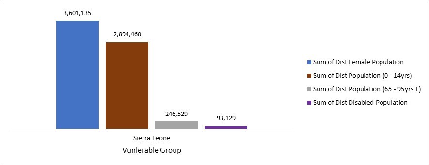
7,092,113 |
3,490,978 |
3,601,135 |
4,187,016 |
2,052,387 |
2,134,629 |
2,905,097 |
1,438,591 |
1,466,506 |